Activity: Hiking | Difficulty: Hard | Location: Carrbridge, Scotland
The Carrbridge Summit Trail is a challenging hiking route that takes you to the highest point near Carrbridge. The trail is an out-and-back route with steep ascents, rocky terrain, and a total distance of approximately 12 kilometers.
Adventure Statistics
- Distance: 12.0km
- Duration: 2h 7m
- Elevation Gain: 350m
- Max Elevation: 550m
- Calories Burned: 954
- Best Seasons: Spring, Summer, Fall
- Features: Viewpoint, Summit, Forest, River, Wildlife_viewing, Historical_site
Photos
Location Overview
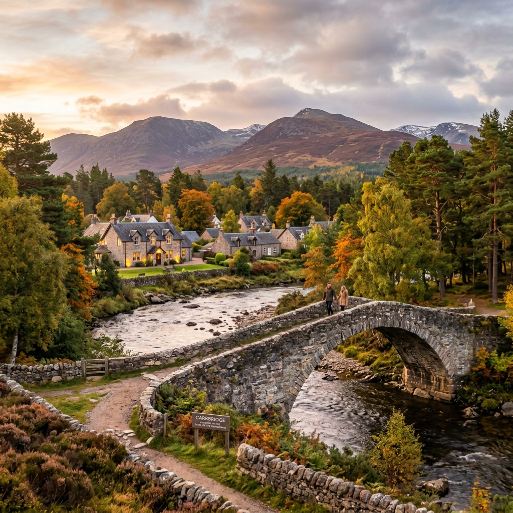
<p>Carrbridge, located in the heart of Inverness-Shire, Scotland, is a small village that serves as a gateway to the Scottish Highlands. Nestled along the River Dulnain, the village is surrounded by a landscape that is both rugged and picturesque, making it an ideal destination for hikers and nature lovers. The area is characterized by rolling hills, dense forests, and open moorlands, each offering a unique and captivating experience. The village itself is steeped in history, with the famous Carrbridge Packhorse Bridge dating back to the 18th century, adding a charming and nostalgic atmosphere to the area.</p><p>The landscape around Carrbridge is a testament to the natural beauty of the Scottish Highlands. The hills rise gently from the valley floor, gradually increasing in elevation and offering hikers a range of terrains to explore. The forests are predominantly composed of Scots pine and birch, providing a lush and vibrant environment that changes with the seasons. In the spring, the woods come alive with the sounds of birdsong and the scent of wildflowers, while the fall brings a palette of rich reds and golds that paint the landscape in warm hues.</p><p>The moorlands, which are a significant feature of the area, are home to a variety of wildlife and offer a sense of openness and freedom that is hard to find elsewhere. The heather-covered hills and peaty bogs are a habitat for birds such as golden plovers and curlews, and the occasional glimpse of a red deer can be a highlight of any hike. The combination of these natural elements makes Carrbridge a perfect destination for those who want to immerse themselves in the beauty of the Scottish countryside.</p><p>For hikers, the area around Carrbridge offers a range of trails that cater to different skill levels and preferences. The Carrbridge Summit Trail, in particular, stands out as a challenging and rewarding route that takes you to the highest point in the vicinity. The trail is well-marked and maintained, ensuring that hikers can enjoy a safe and enjoyable experience. Whether you're looking for a short walk or a full-day adventure, the area around Carrbridge has something to offer everyone.</p>
Key Points of Interest
<p>The Carrbridge Summit Trail is marked by several key points and landmarks that make the journey both memorable and rewarding. One of the first notable points you'll encounter is the <strong>Woodland Clearing</strong>, a small open area where the forest thins out, offering a brief respite from the trees and a chance to catch your breath. From here, you can see the hills rising in the distance, giving you a sense of the challenge ahead.</p><p>As you continue along the trail, you'll reach the <strong>Heather Moor</strong>, a vast expanse of heather-covered land that stretches out before you. The moorland is particularly beautiful in late summer when the heather is in full bloom, painting the landscape in shades of purple and pink. This section of the trail is relatively flat, making it a good place to take a break and enjoy the views.</p><p>Further along, you'll come to the <strong>Rocky Outcrop</strong>, a prominent feature that offers panoramic views of the surrounding area. The outcrop is a popular spot for hikers to stop and take photos, and it's a great place to enjoy a snack or a drink while you soak in the scenery. The rocky terrain here is a testament to the area's geological history, and you can see the layers of rock that have been exposed by erosion over time.</p><p>One of the highlights of the trail is the <strong>Summit Viewpoint</strong>, which is the highest point on the route. From the summit, you can see for miles in every direction, taking in the rolling hills, the River Dulnain, and the patchwork of fields and forests that characterize the Scottish countryside. On a clear day, you may even be able to see the distant peaks of the Cairngorms, adding to the sense of achievement and wonder.</p><p>As you begin your descent, you'll pass through the <strong>Forest Glade</strong>, a peaceful and secluded area where the forest canopy provides a natural canopy. The glade is a tranquil spot, and the dappled sunlight filtering through the trees creates a magical atmosphere. This section of the trail is particularly beautiful in the early morning or late afternoon when the light is soft and the air is cool.</p><p>Before you reach the end of the trail, you'll come to the <strong>River Crossing</strong>, a small stream that you need to navigate. The crossing is usually shallow and easy to manage, but it's a good idea to take your time and watch your step, especially if the water is running high after heavy rain. The sound of the flowing water and the fresh scent of the forest make this a refreshing and invigorating part of the hike.</p>
Route Waypoints
- Woodland Clearing: A small open area where the forest thins out, offering a brief respite from the trees.
- Heather Moor: A vast expanse of heather-covered land, particularly beautiful in late summer.
- Rocky Outcrop: A prominent feature offering panoramic views of the surrounding area.
- Summit Viewpoint: The highest point on the route, with breathtaking 360-degree views.
- Forest Glade: A tranquil and secluded area with a natural canopy of trees.
- River Crossing: A small stream that you need to navigate on your descent.
Getting to the Start
<p>To reach the start of the Carrbridge Summit Trail, you can begin your journey from the village of Carrbridge itself. The trailhead is located just a short distance from the center of the village, making it easily accessible by car or public transport. If you're driving, the A95 road runs through Carrbridge, and you can park at the Carrbridge Community Centre car park, which is located on the eastern edge of the village. The car park is well-maintained and can accommodate a moderate number of vehicles, though it can get busy during peak hiking seasons. There is no charge for parking, making it a convenient and cost-effective option.</p><p>For those traveling by public transport, the nearest train station is in Aviemore, which is about 15 kilometers north of Carrbridge. From Aviemore, you can take a local bus service that runs to Carrbridge, with stops near the village center. The bus timetable is reliable, and the journey takes approximately 30 minutes, providing a scenic and comfortable way to reach the trailhead. Alternatively, you can use the Stagecoach bus service, which offers connections to Carrbridge from various nearby towns and villages.</p><p>Once you arrive in Carrbridge, the trailhead is well-signposted and easy to find. From the Carrbridge Community Centre car park, follow the path that leads north towards the forest. The trailhead is marked with a wooden signpost that clearly indicates the start of the Carrbridge Summit Trail. From here, you can begin your adventure, knowing that you are well-prepared and ready to tackle the challenges that lie ahead.</p>
Tips, Safety & Travel
<p>When planning your hike on the Carrbridge Summit Trail, it's important to be prepared for the challenges and conditions that you may encounter. The trail is well-marked and maintained, but it is a challenging route that is best suited for experienced hikers. The terrain is varied, with steep ascents, rocky sections, and uneven ground, so it's essential to wear appropriate footwear and clothing. Sturdy hiking boots with good ankle support are recommended, and you should dress in layers to accommodate changes in temperature and weather.</p><p>The best time to hike the Carrbridge Summit Trail is during the summer months when the weather is generally more stable and the days are longer. However, the Scottish Highlands can experience sudden changes in weather, so it's a good idea to check the forecast before you set out and to be prepared for rain or wind. Carrying a waterproof jacket and a hat is always a wise precaution, and you may also want to bring a lightweight poncho or rain cover for your backpack.</p><p>In terms of safety, it's important to let someone know your planned route and expected return time, especially if you are hiking alone. Carrying a map and compass is recommended, even if you have a GPS device, as it's always a good idea to have a backup navigation tool. A first-aid kit, a whistle, and a fully charged mobile phone are also essential items to have with you. If you encounter any difficulties or need assistance, the nearest emergency services can be reached by dialing 999.</p><p>Finally, be mindful of the environment and respect the natural and historical features of the area. Stay on marked trails to avoid damaging the fragile ecosystem, and take all your litter with you. By following these tips and being prepared, you can ensure that your hike on the Carrbridge Summit Trail is a safe, enjoyable, and memorable experience.</p>
Wildlife & Nature Highlights
<p>The Carrbridge Summit Trail is not only a haven for hikers but also a rich ecosystem that supports a diverse array of wildlife. As you make your way along the trail, you'll have the opportunity to observe a variety of flora and fauna that are native to the Scottish Highlands. The forests along the route are home to a range of bird species, including the common buzzard, red kite, and the elusive capercaillie. The dense canopy provides a natural habitat for these birds, and you may hear their calls or catch a glimpse of them soaring overhead.</p><p>On the ground, the forest floor is carpeted with a variety of plants, including heather, bilberry, and blaeberry. These plants not only add color and texture to the landscape but also serve as a food source for small mammals and insects. Keep an eye out for red squirrels, which are a common sight in the area, and listen for the rustling of leaves as they scurry through the undergrowth. The moorlands, which are a significant part of the trail, are home to a variety of ground-nesting birds, such as the golden plover and the curlew. These birds are well-camouflaged, but their distinctive calls can often be heard as you hike.</p><p>The river and streams that flow through the area are also teeming with life. The River Dulnain, which runs through Carrbridge, is a habitat for salmon and trout, and you may see anglers along its banks. The riverbanks are lined with alders and willows, providing a shaded and peaceful environment. In the summer months, dragonflies and damselflies can be seen darting over the water, adding a touch of color and movement to the scene.</p><p>The geology of the area is another highlight of the Carrbridge Summit Trail. The hills and moorlands are underlain by ancient rocks, including granite and quartzite, which have been shaped by millions of years of erosion and glaciation. The rocky outcrops and boulder fields that you encounter along the trail are a testament to the area's geological history. The soil in the region is often peaty and acidic, which supports the growth of heather and other acid-loving plants. The combination of these natural elements creates a unique and dynamic ecosystem that is a delight to explore.</p>
Tags
- hiking
- scenic views
- challenging
- outdoor adventure
- nature
- wildlife
- Scottish Highlands
- Carrbridge